7.3 Types of Volcanism
Steve Earle
There are numerous types of volcanism; some of the more common ones are summarized in Table 7.3.1.
| Type | Tectonic Setting | Size & Shape | Magma & Eruption Characteristics | Example |
| Cinder cone | Various. Some form on the flanks of other volcanoes | Small (10s to 100s of m) and steep (>30°) | Most are mafic and form from the gas-rich early stages of a shield- or rift-associated eruption | Eve Cone, northern BC |
| Composite volcano | Almost all are at subduction zones | Medium size (1000s of m) and moderate steepness (10 to 30°) | Magma composition varies from felsic to mafic, and from explosive to effusive | Mt. St. Helens |
| Shield volcano | Most are at mantle plumes, some on spreading ridges | Large (up to several 1000 m high and 200 km across), not steep (typically 2 to 10°) | Magma is almost always mafic, and eruptions are typically effusive, although cinder cones are common on the flanks of shield volcanoes | Kilauea, Hawaii |
| Large igneous provinces | Associated with “super” mantle plumes | Enormous (up to millions of km2) and 100s of m thick | Magma is always mafic. Individual flows can be 10s of metres thick | Columbia River basalts |
| Sea-floor volcanism | Generally associated with spreading ridges but also mantle plumes | Most of the oceanic crust formed at spreading ridges | At normal eruption rates pillows form. At faster rates, lava flows develop. | Juan de Fuca ridge |
| Kimberlite | Older parts of continents | The remnants are typically 10s to 100s of m across | Most appear to have had explosive eruptions forming cinder cones. The youngest one is over 10 ka, and all others are over 30 Ma. | Lac de Gras kimberlite field, NWT |
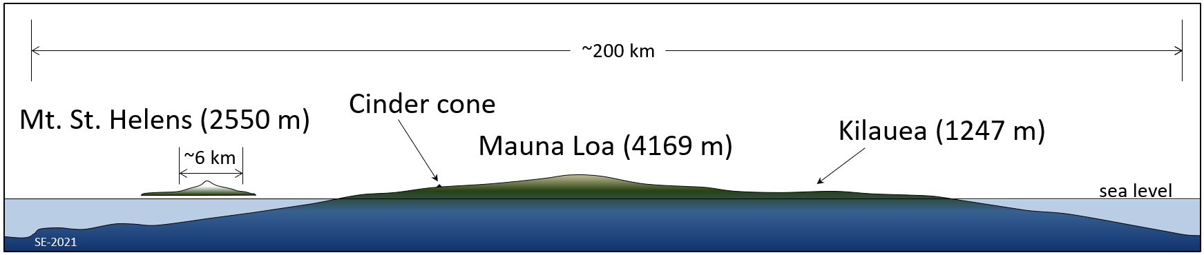
The sizes and shapes of typical shield, composite and cinder-cone volcanoes are compared on Figure 7.3.1, although, to be fair, Mauna Loa is the largest shield volcano on Earth, all others are smaller. Mauna Loa rises from the surrounding flat sea floor, and its full diameter is in the order of 200 km, with a diameter of about 100 km above sea level. Its elevation is 4169 m above sea level. Mt. St. Helens, a composite volcano, rises above the surrounding hills of the Cascade Range. It is about 6 km across at the base, and its height is 2550 m above sea level. Cinder cones are much smaller. On this drawing even a large cinder cone is just a dot.
Cinder Cones
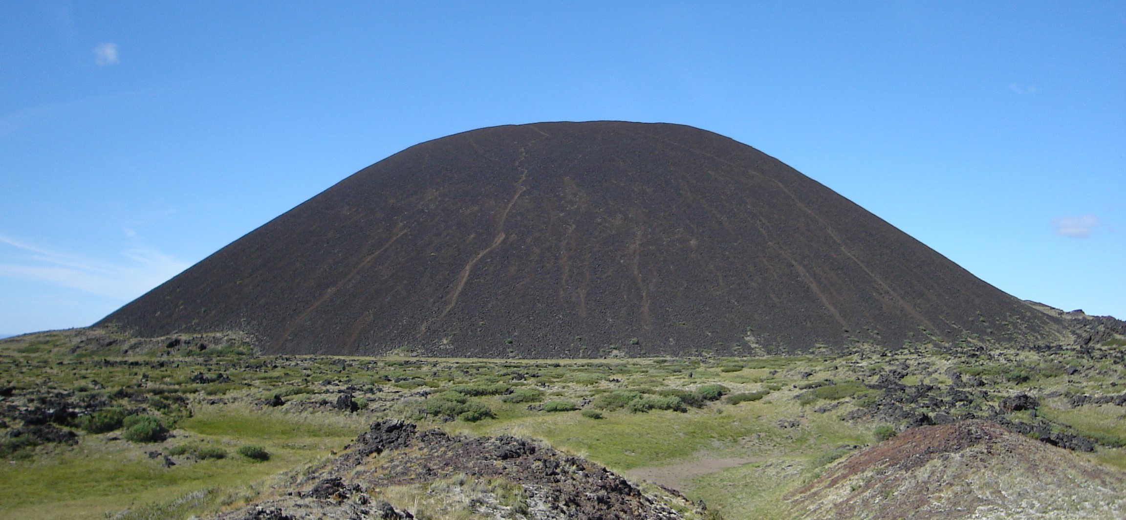
Cinder cones, like Eve Cone in northern BC (Figure 7.3.2), are typically only a few hundred metres in diameter and few are more than 200 m high. Most are comprised of fragments of vesicular mafic volcanic rock that were blasted out during a high-gas-pressure early phase of an eruption that may have subsequently become effusive (lava flows). Most cinder cones are monogenetic, meaning that they were created during a single eruptive phase that might have lasted weeks or months. Because cinder cones are made up almost exclusively of loose fragments, they have very little strength and can be easily, and relatively quickly, eroded away.
Composite Volcanoes
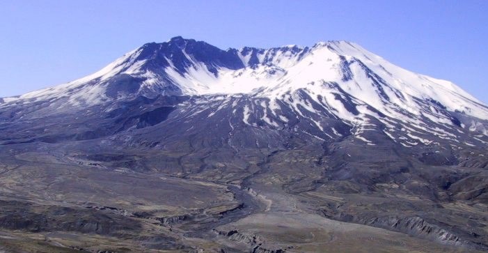
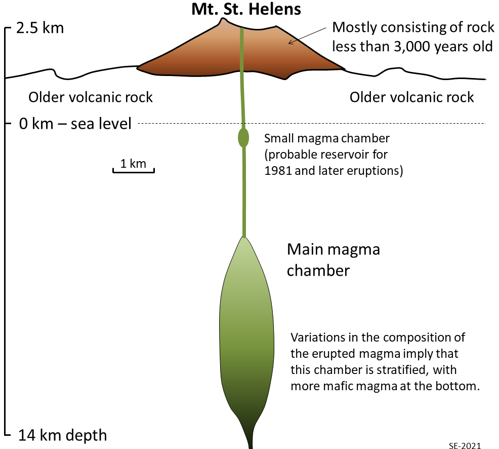
Composite volcanoes, like Mt Merapi in Java (Figure 7.0.1) or Mt. St. Helens in Washington State (Figure 7.3.3), are almost all associated with subduction at convergent plate boundaries—either ocean-continent or ocean-ocean boundaries (Figure 7.1.2b). At many such volcanoes magma is stored in a magma chamber in the upper part of the crust. For example, at Mt. St. Helens, there is evidence of a magma chamber that is approximately 1 kilometre in width and extends from about 6 to 14 km depth below surface (Figure 7.3.4). Systematic variations in the composition of volcanism over the past several thousand years at Mt. St. Helens imply that the magma chamber is zoned, from more felsic at the top to more mafic at the bottom.
The rock that makes up Mt. St. Helens ranges in composition from rhyolite (Figure 7.3.5a) to basalt (Figure 7.3.5b), and that implies that the types of past eruptions have varied widely in their character. As already noted, felsic magma doesn’t flow easily and doesn’t allow gases to escape easily. Under these circumstances pressure builds up until some part of the volcano gives way, and then an explosive eruption results, producing pyroclastic debris, as shown on Figure 7.3.5a. This type of eruption can also lead to rapid melting of ice and snow on a volcano, and that typically triggers large mudflows known as lahars (Figure 7.3.5a). Hot, fast moving pyroclastic flows and lahars are the two main causes of casualties in volcanic eruptions. Pyroclastic flows killed approximately 30,000 during the 1902 eruption of Mt. Pelée on the Caribbean island of Martinique. Most were incinerated in their homes. In 1985 a massive lahar, triggered by the eruption of Nevado del Ruiz, killed 23,000 in the Columbian town of Armero, about 50 km from the volcano.
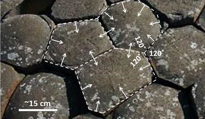
In contrast, mafic eruptions (and some intermediate eruptions), produce lava flows and the one shown on Figure 7.3.5b is thick enough (about 10 m in total) to have cooled in a columnar jointing pattern (Figure 7.3.6). Lava flows serve to both flatten the profile of the volcano (because the lava typically flows farther than the pyroclastic debris falls) and also to protect it from erosion. Even so, composite volcanoes tend to erode quite quickly. Patrick Pringle, a volcanologist formerly with the Washington State Department of Natural Resources describes Mt. St. Helens as a “pile of junk”.
In a geological context, composite volcanoes tend to form relatively quickly and do not last very long. Mt. St. Helens, for example, is made up of rock that is all younger than 40,000 years; most of it is younger than 3,000 years. If its volcanic activity ceases, then it might erode away within a few tens of thousands of years. This is largely because of the presence of pyroclastic eruptive material, which is quite weak because it is made up of fragments that are not well stuck together.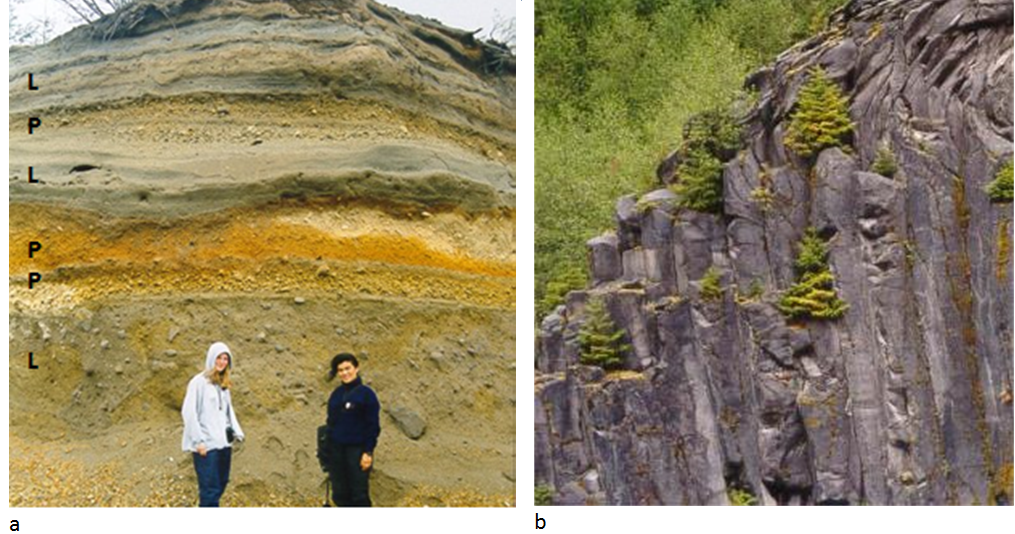
Figure 7.3.5 Mt. St. Helens Volcanic Deposits. (a) lahar deposits (L) and felsic pyroclastic deposits (P); and (b) a columnar basalt lava flow. The two photos were taken at locations only about 500 m apart.
Exercise 7.3 Volcanoes and Subduction
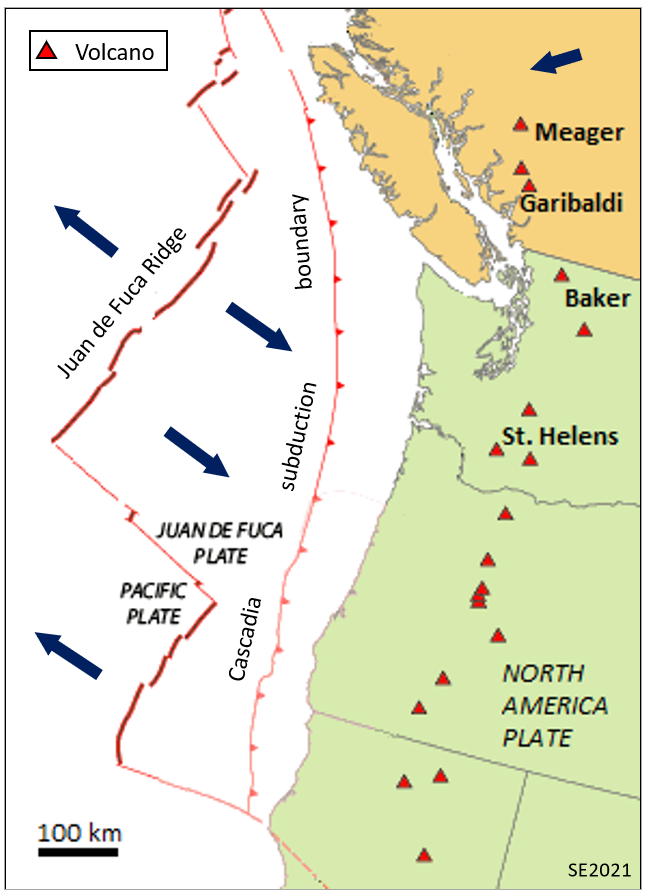
Figure 7.3.7 illustrates the interactions between the North America, Juan de Fuca and Pacific plates off the west coast of Canada and the US. The Juan de Fuca plate is being formed along the Juan de Fuca ridge, and is then subducted beneath the North America plate along the red line with teeth on it (“Cascadia subduction boundary”)
- Using the scale bar in the lower left, estimate the average distance between the subduction boundary and the Cascadia composite volcanoes. (Compare that result with the distance between the subduction boundary and the volcanoes shown on Figure 7.0.2 above.)
- If the subducting Juan de Fuca plate descends 40 km for every 100 km that it moves inland, what is its likely depth of the subducting plate in the area directly beneath the existing volcanoes?
Exercise answers are provided Appendix 2.
Shield Volcanoes
Most shield volcanoes are associated with mantle plumes, although some form at divergent boundaries, either on land or on the sea floor. The best-known shield volcanoes are those that make up the Hawaiian Islands, and of these the only active ones are on the big island of Hawaii. Mauna Loa, the world’s largest volcano and the world’s largest mountain (by volume) last erupted in 1984. Kilauea, arguably the world’s most active volcano, erupted almost continuously, from 1983 to 2018, and then started up again in late 2020. Loihi is an underwater volcano on the southeastern side of Hawaii. It is last known to have erupted in 1996, but may have erupted since then without being detected.
All of the Hawaiian volcanoes are related to the mantle plume that currently lies beneath Mauna Loa, Kilauea and Loihi (Figure 7.3.8). In this area the Pacific Plate is moving northwest at a rate of about 7 cm/year, and this means that the earlier formed—and now extinct—volcanoes have now moved well away from the mantle plume. As shown on Figure 7.3.8, there is evidence of crustal magma chambers beneath all three active Hawaiian volcanoes. At Kilauea the magma chamber appears to be several kilometres in diameter and is situated between 8 and 11 km below surface.

Although it is not a prominent mountain (seen in Figure 7.3.1), there is a large caldera in the summit area of Kilauea volcano (Figure 7.3.9). A caldera is a volcanic crater that is more than 2 km in diameter; this one is 4 km long and 3 km wide. It contains a smaller feature called Halema’uma’u crater that has a total depth of over 200 m below the surrounding area. Most volcanic craters and calderas are formed above magma chambers, and the level of the crater floor is influenced by the amount of pressure exerted by the magma body. During historical times the floors of both Kilauea caldera and Halema’uma’u crater have moved up—during expansion of the magma chamber—and down—during deflation of the chamber.[1]
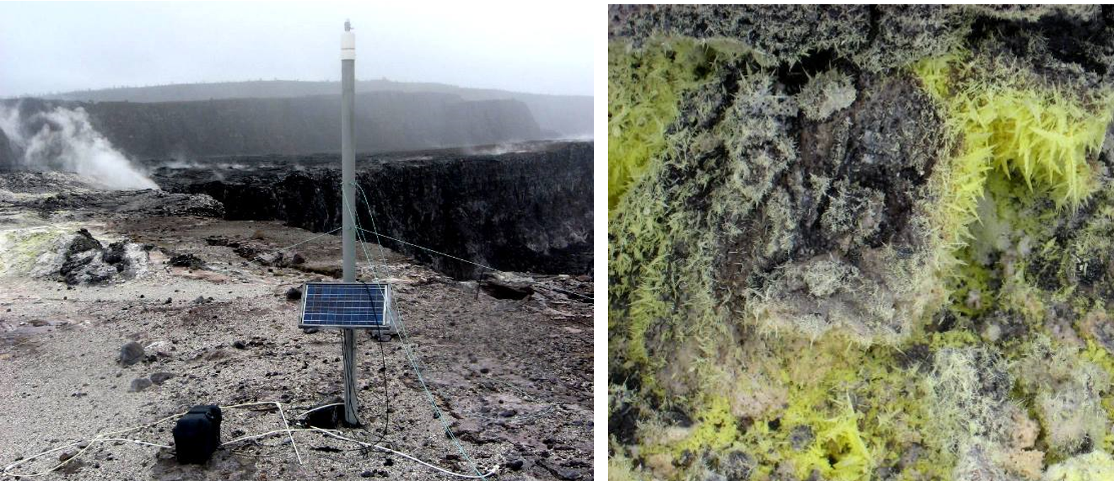
One of the conspicuous features of Kilauea caldera is the sight of rising water vapour (the white cloud in Figure 7.3.9) and a strong smell of sulphur (Figure 7.3.10). As is typical in magmatic regions, water is the main volatile component, followed by carbon dioxide and sulphur dioxide. These, and some minor gases, originate from the magma chamber at depth and rise up through cracks in the overlying rock. This degassing of the magma is critical to the style of eruption at Kilauea, which, for most of the past 30 years, has been effusive, not explosive.
Kilauea started forming at approximately 300 ka, while neighbouring Mauna Loa began to form at about 700 ka and Mauna Kea at about 1 Ma. If volcanism continues above the Hawaii mantle plume in the same manner that it has since 85 Ma, it is likely that Kilauea will continue to erupt for at least another 500,000 years. By that time its neighbour, Loihi, will likely have emerged from the sea floor, and its other neighbours, Mauna Loa and Mauna Kea, will have become significantly eroded.
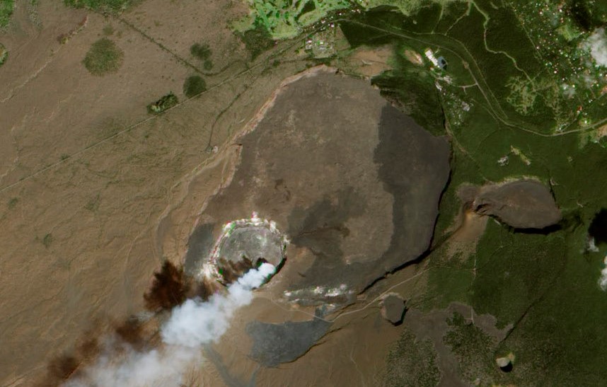
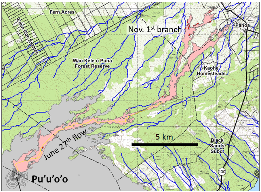
Exercise 7.4 Kilauea’s June 2015 Lava Flow
The U.S. Geological Survey Hawaii Volcano Observatory (HVO) map below (Figure 7.3.11), shows the outline of lava that started flowing northeast from Pu’u’o’o on June 27th 2015 (the “June 27th Lava flow”, a.k.a. the “East Rift Lava Flow”). The flow reached the nearest settlement, Pahoa, on October 29th, after covering a distance of 20 km in 124 days. After damaging some infrastructure west of Pahoa, the flow stopped advancing. A new outbreak formed November 1st, branching out to the north from the main flow about 6 km southwest of Pahoa.
What is the average rate of advance of the flow front from June 27th to October 29th, 2015 – in m/day and m/hour?
Exercise answers are provided Appendix 2.
Large Igneous Provinces
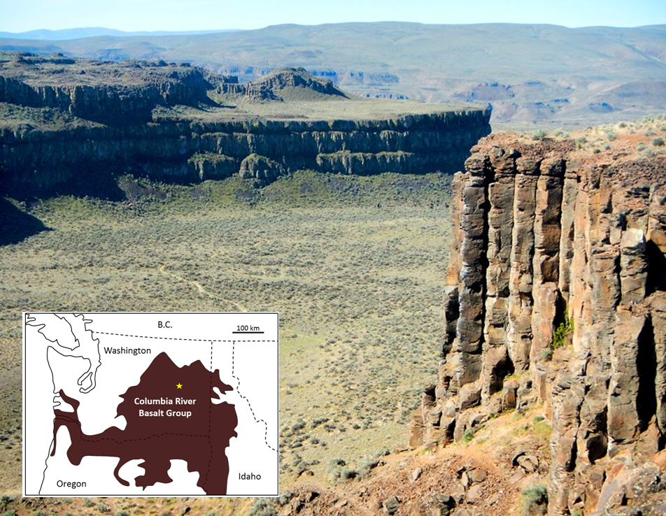
While the Hawaii mantle plume has produced magma at a relatively slow rate for a very long time (at least 85 million years), other mantle plumes are less consistent, and some generate massive volumes of magma over relatively short time periods. Although their origin is still controversial, it is thought that the volcanism leading to large igneous provinces (LIP) is related to very high volume but relatively short duration bursts of magma from mantle plumes[2]. An example of an LIP is the Columbia River Basalt Group (CRGB), which extends across Washington, Oregon and Idaho (Figure 7.3.12). This volcanism, which covered an area of about 160,000 km2 with basaltic rock up to several hundred metres thick, took place between 17 and 14 Ma.
Some other LIP eruptions have been much bigger. The eruption of the Siberian Traps (also basalt), which happened at the end of the Permian period, at 250 Ma, is estimated to have been 40 times the volume of the CRBG, and is thought to have been responsible for the greatest extinction of all time.
The mantle plume that is assumed to be responsible for the CRBG is now situated beneath the Yellowstone area in Wyoming, where it is associated with felsic volcanism. Over the past 2 million years three very large explosive eruptions at Yellowstone have yielded approximately 900 km3 of felsic magma, about 900 times the volume of the 1980 eruption of Mt. St. Helens, but only 5% of the volume of mafic magma in the CRBG.
Sea Floor Volcanism
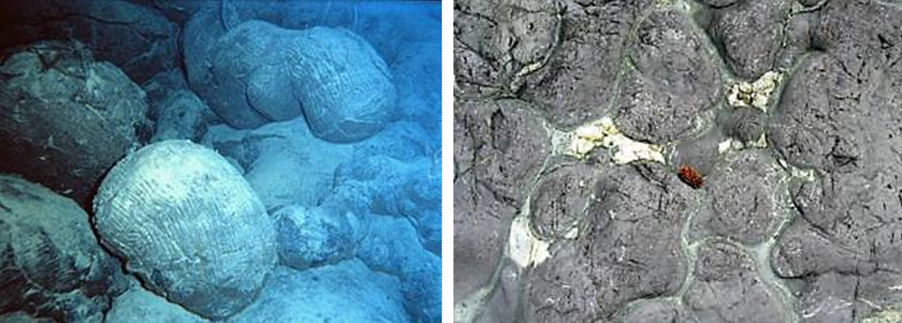
Some LIP eruptions occur on the sea floor, the largest being the one that created the Ontong Java plateau in the western Pacific Ocean at around 122 Ma. But most seafloor volcanism originates at divergent boundaries and involves relatively low volume eruptions. Under these conditions, hot lava that oozes out in the cold seawater quickly cools on the outside and then behaves a little like toothpaste. The resulting blobs of lava are known as pillows, and they tend to form piles around a sea-floor lava vent (Figure 7.3.13). In terms of area, there is very likely more pillow basalt on the sea floor than any other type of rock on Earth.
Kimberlites
While all of the volcanism discussed so far is thought to originate from partial melting in the upper mantle or within the crust, there is a special class of volcanoes—kimberlites—that have their origins much deeper in the mantle, at depths of 150 to 450 km. During a kimberlite eruption material from this depth may make its way to surface quite quickly (hours to days) and with little interaction with the surrounding rocks. As a result, kimberlite eruptive material is representative of mantle compositions—it is ultramafic.
The pressure and temperature suitable for diamonds to form exist in the mantle at depths of 160 to 190 km within areas of old thick crust (shields). Kimberlite eruptions that originate at greater depth traverse this region of diamond stability, and, in some cases bring diamond-bearing rock to the surface. All of the diamond deposits on Earth are assumed to have formed in this way; an example is the rich Ekati Mine in the Northwest Territories (Figure 7.3.14).
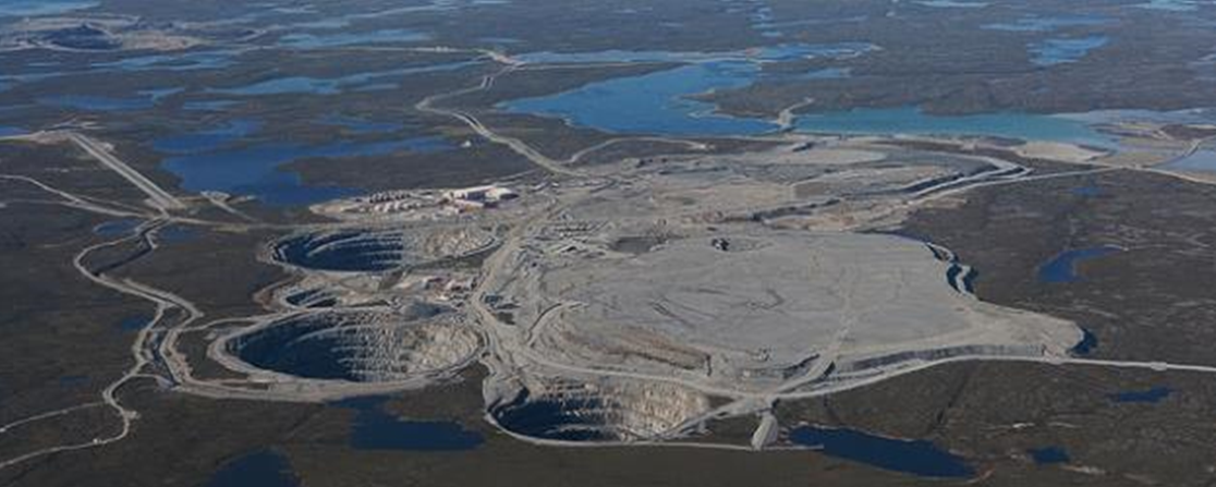
The kimberlites at Ekati erupted between 45 and 60 Ma. Many kimberlites are older— some much older—but there have been no kimberlite eruptions in historic times. The youngest known kimberlites are at the Igwisi Hills in Tanzania, aged about 10,000 years, and the next youngest known are dated to about 30 Ma.
Media Attributions
- Figure 7.3.1 Steven Earle, CC BY 4.0
- Figure 7.3.2 Eve Cone by FortGirl, 2007, via Flickr, CC BY SA NC 2.0, https://www.flickr.com/photos/fortgirl/2184491354/in/photostream/
- Figure 7.3.3 Photo by Steven Earle, CC BY 4.0
- Figure 7.3.4 Steven Earle, CC BY 4.0, after Pringle, P. T., & Washington (State). Division of Geology and Earth Resources. (1993). Roadside geology of Mount St. Helens National Volcanic Monument and vicinity. Information circular/Washington Department of Natural Resources, Division of Geology and Earth Resources, 88. https://www.dnr.wa.gov/Publications/ger_ic88_mount_st_helens_pt1.pdf
- Figure 7.3.5 Photos by Steven Earle, CC BY 4.0
- Figure 7.3.6 Steven Earle, CC BY 4.0
- Figure 7.3.7 Steven Earle, CC BY 4.0
- Figure 7.3.8 Hotspot Cross-Sectional Diagram by J. E. Robinson, (2006). US Geological Survey public domain image via Wikimedia Commons, https://commons.wikimedia.org/wiki/File:Hawaii_hotspot_cross-sectional_diagram.jpg)
- Figure 7.3.9 Kilauea, NASA, public domain, via Wikimedia Commons, https://commons.wikimedia.org/wiki/File:Kilauea_ali_2012_01_28.jpg
- Figure 7.3.10 Photos by Steven Earle, CC BY 4.0
- Figure 7.3.11 Map from US Geological Survey & Hawaiian Volcano Observatory, Public domain, https://www.usgs.gov/observatories/hvo
- Figure 7.3.12 Photo and inset drawing by Steven Earle, CC BY 4.0
- Figure 7.3.13 Photo by Steven Earle, CC BY 4.0
- Figure 7.3.14 Ekati mine by Jason Pineau, 2010, CC BY SA 3.0, via Wikimedia Commons, https://commons.wikimedia.org/wiki/File:Ekati_mine_640px.jpg
- The Kilauea Caldera, and especially the Halemaʻumaʻu crater within it, started changing quite significantly in 2020. The bottom of the crater first subsided, and then it began filling with lava in December 2020, forming a body that is up to 170 m thick. As of late May 2021, the volcano is quiet, but there is no way of knowing how long the quiet interval will last. The Hawaii Volcano Observatory publishes daily updates on activity at Kilauea at: https://www.usgs.gov/observatories/hawaiian-volcano-observatory ↵
- Bryan, S. & Ernst, R. (2007). Revised definition of large igneous provinces (LIPs). Earth-Science Reviews, 86(1-4), 175-202. https://doi.org/10.1016/j.earscirev.2007.08.008 ↵