12.5 Origin and Genesis of Caves
Steve Earle
The origin and genesis of karst caves has been a hotly debated subject in both geological and speleological circles for centuries. Are caves formed above the water table (vadose conditions), below the water table (phreatic conditions), along the water table (hypophreatic), from hydrothermal water sources or by some other processes?
More recently there appears to be some consensus to this question – not always the way in science! Approximately 90% of known karst caves are thought to have formed from meteoric water sources (i.e., from water that has originated from the surface.) A small percentage of caves have formed by warm hydrothermal solutions emanating from deeper sources in the Earth (such as from a slow cooling granitic body), with H2S mainly being responsible for making the acidic waters available for bedrock dissolution. This is known a hypogenic karst.
The generally accepted hypothesis for karst cave genesis is as follows. Meteoric water falling or flowing onto the karst landscape infiltrates the ground surface and percolates through the vadose zone down to the water table – below which all cavities are filled with water. Water in the phreatic zone, below the water table, flows slowly towards an output, such as a spring at a topographic low. As this water flows from the input to output sites it creates a U-shaped conduit known as a ‘phreatic loop’, which extends for some distance underground. The depth of this loop is dependent on the orientation of primary structures within the bedrock (e.g., bedding planes and joints) and the distance between the sites of water input and output. The greater the distance between input and output and the steeper the bedding planes, the deeper the phreatic loop. (Trying to fully prove this concept by direct observation moves into the realm of cave diving—a highly skilled and hazardous research technique!) Most caves are thought to have initially formed in this way with the phreatic loop forming a trunk or main passage for the cave. Other side passages can form above, below and along the sides of this preferred loop, and may link up with other main passages.
The landscape and the associated water table is likely to fall or rise over time, possibly due to changes in sea level and/or tectonic uplift or subsidence. This has a major effect on the cave formation process. If the water table rises (e.g., if the ground subsides, or the sea level rises) the locations of water input and output will change. Solution process along the phreatic loop will cease as water flow will become very slow or stationary.
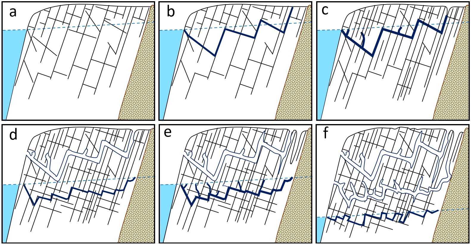
Caves above the phreatic zone, if any, will become water-filled and used as preferential sites for water flow (i.e., the vadose cave system will become reactivated). On the other hand, if the water table is lowered as the landscape becomes uplifted, a new deeper phreatic loop will develop, while the older phreatic loop will become partially air-filled (vadose) with a stream channel along the floor of the passage. This stream channel will flow faster and likely contain coarse clastic sediments that will erode and cut into the phreatic tube, and possibly form a small slot, such as a keyhole passage. Sediments could also be moved and redeposited, and seepage/drips would form speleothems on the ceiling and walls. As the new phreatic loop continues to develop below the vadose passage it could potentially capture the stream above and lead to ‘drying’ of the vadose passage. As might be anticipated with continental tectonic uplift and dissolution, a multi-level cave system could develop. However, over long geologic periods this can be complicated by changes in climate (e.g., ice ages, glaciation, and de-glaciation), as well as the rates of tectonic movements. Some of these processes are illustrated on Figure 12.5.1.
This well accepted model of multi-level cave development by Ewers and Ford (1978)[1] is based on the premise of a lowering base level (water table) over time, which might occur during the incision of a major river valley, tectonic uplift, or by changes in sea level. The model demonstrates a gradual increase in the frequency of enlarged fractures or fissures (black lines) during the dissolution of carbonate bedrock by infiltrating water that moves from the surface to output sites (on the left side of images). These output sites might occur as karst springs near a valley bottom. In b) a water filled conduit (solid blue lines) develops along a phreatic loop as fissures become enlarged and forming a cave in c) connecting input and output sites. As the base level lowers in d) and e) a second phreatic loop develops along the new water table, leaving the upper cave air filled (open blue lines) and in the vadose zone. With final lowering of base level in f) a third phreatic loop develops near the water table abandoning the previous two loops and caves above and leaving them both in the vadose zone.
The time of inception to the end of cave formation is not clearly defined. However, the answer is in part linked rates of erosion, and denudation of karst landscapes. Most of the research suggests that 3000-5000 years is required for a proto-cave 5-15 mm in size to develop, and 5000-100,000 years is required to form an opening 1-10 m or more.[2] This is of course speculative and depends on the continuity of the solution process and many other possible variables (e.g., climate, tectonic uplift, and glaciation). A variety of analytical techniques can be used to directly date materials found in a cave. Fossils in cave sediments can be dated using 14C and speleothems can be dated using 234U-230Th techniques. This information can place constraints on the time for cave formation. For example, speleothems from Castleguard Cave (the longest known cave in Canada, located along the BC-Alberta border) were dated at 780,000 years, indicating that the main episode of cave development liked ended at or near this time, and the passages probably formed many thousands of years earlier. On Vancouver Island speleothems have been dated at 15,000 – 18,500 years, suggesting caves could be of younger origin.[3].
Studies from south-east Australia suggest that some caves in that region are in the order of 300 million years old.[4]. If this is correct, we could, when entering these caves, be going into environments that have been basically unchanged for vast periods of geologic time. Overall, the determination of a cave’s age is not clear cut, particularly when it is difficult to construe when cave development begins and when it ends. It is quite possible for old cave passages to be uplifted and ‘dried out’, then submerged, re-developed, and then uplifted again. The only sure end to cave development is when it is uplifted and totally eroded away!
Media Attribution
- Figure 12.5.1 Steven Earle, CC BY 4.0, after Ford and Ewers (1978)
- Ford, D. and Ewers, R. (1978). The development of limestone cave systems in the dimensions of length and depth. International Journal of Speleology, 10: 213-244. http://dx.doi.org/10.5038/1827-806X.10.3.1 ↵
- White, B. (1988). Geomorphology and hydrology of karst terrains. Oxford University Press. ↵
- Stokes, T. R., & Griffiths, P. A. (2019). An Overview of the Karst Areas in British Columbia, Canada. Geoscience Canada, 46(1), 49–66. https://doi.org/10.12789/geocanj.2019.46.145 ↵
- Armstrong, O. (2003). The world’s oldest cave – how did they survive and what can they tell us? Acta Carsologica, 36(1), 134–142. https://doi.org/10.3986/ac.v36i1.215 ↵