2.4 Plate Tectonics
Steve Earle
The lithosphere (the upper rigid mantle plus the crust) is divided into a number of pieces known as plates that can move around on the Earth’s surface, all in different directions and at different rates. The behaviour of these plates: their motions and their interactions with each other is known as plate tectonics, where the word “tectonics” refers to the deformation of rocks. The distributions of the plates are shown on Figure 2.4.1; the seven major ones are as follows:
- North America Plate: underlies most of North America, part of eastern Russia, part of the Arctic Ocean and the northwestern part of the Atlantic Ocean,
- Eurasia Plate: underlies Europe, much of Asia and the northeastern part of the Atlantic Ocean,
- Pacific Plate: underlies much of the Pacific Ocean,
- Africa Plate: underlies Africa, the southeastern Atlantic Ocean, and the western Indian Ocean,
- South America Plate: underlies South America and the southwestern Atlantic Ocean,
- Indo-Australian Plate (includes Australia and India Plates): underlies India, Australia, and parts of the surrounding Indian and Pacific Oceans and islands therein, and
- Antarctic Plate: underlies Antarctica and most of the Southern Ocean.
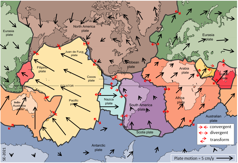
Some of the minor plates shown on Figure 2.4.1 include the Juan de Fuca, Cocos and Nazca Plates along the western edge of N. America, the Caribbean Plate, and the Scotia, Arabia and Filipino Plates. There are several other smaller plates not shown on this map.
The generalized plate motions are shown on Figure 2.4.1. Plate motions range from roughly 1 to 10 cm/y. As can be seen on the map, parts of individual plates are moving in different directions and at different rates. That’s not because the plates are squeezing and stretching (although that does happen near to plate boundaries) but because the plates are all moving in a rotational way, each around a different rotational axis. The North America Plate is moving counter-clockwise around an axis in the southern hemisphere, so the rate of motion is greater in the far north than in the south, and it changes from “towards the northwest” in the east to “towards the southeast” in the west.
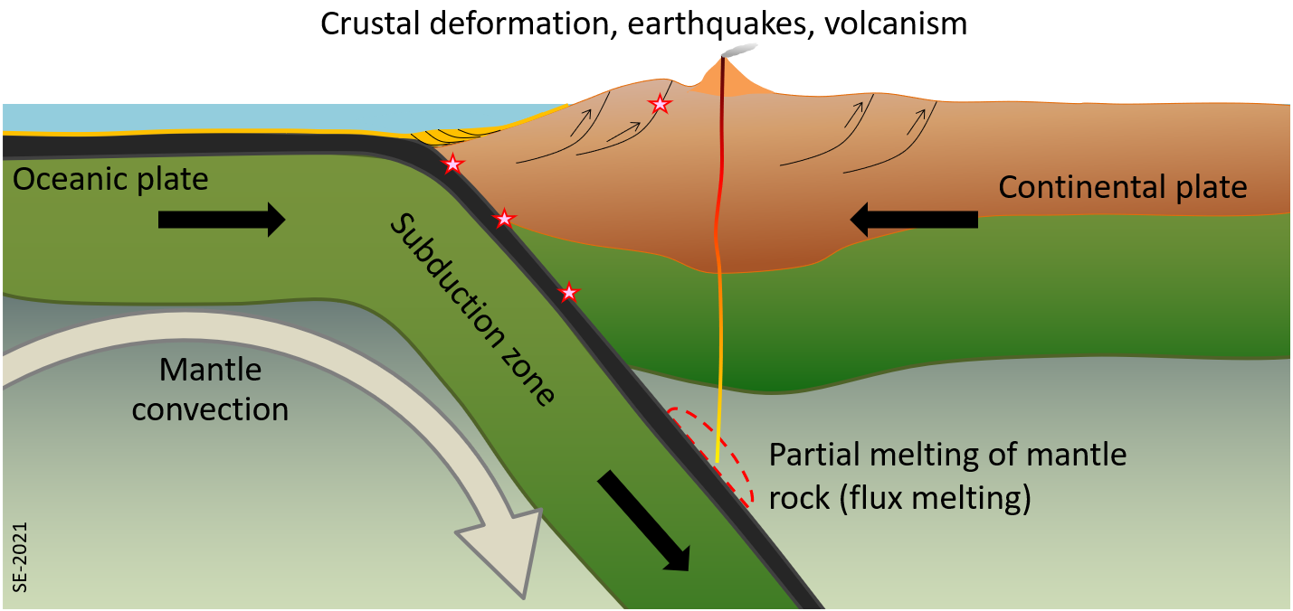
At plate boundaries the interaction between plates can be: convergent (moving towards each other), divergent (moving away from each other), or transform (moving side by side). A convergent boundary is illustrated on Figure 2.4.2. In this case a plate comprised of oceanic crust is moving towards one comprised of continental crust. Because oceanic crustal is denser than continental crust, the oceanic plate gets pushed down—or subducted—beneath the continental plate. That has some important implications, as shown. First, is that there is friction between the two plates, which results in periodic earthquakes, some of which can be very large. Second, is that the subducted oceanic crust gets heated and some of the free water and water held in minerals is released and starts to rise towards surface (more on this below). This water mixes with the hot rocks of the asthenosphere and that reduces their melting temperature (so more melting takes place) creating magma that moves towards surface.
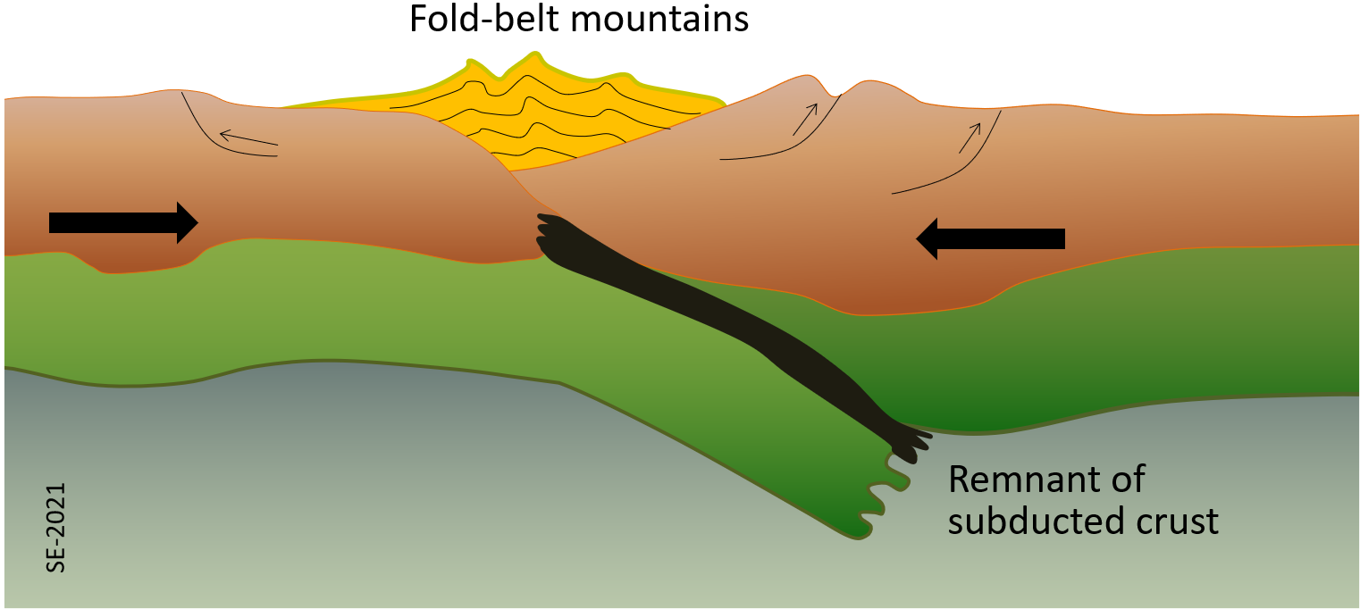
As an oceanic plate converges with a continental plate (in the manner shown on Figure 2.4.2) it is possible that a continent or island will be moving along with that oceanic lithosphere and that the two areas of continental lithosphere will eventually collide. This scenario is illustrated on Figure 2.4.3. In this situation the continental lithosphere cannot be subducted because it isn’t sufficiently dense to be pushed down into the mantle. As the continents collide the sediments that had accumulated along their edges get pushed up to form fold-belt mountains and the older crustal rocks also get deformed and pushed up. The leading edge of the subducted oceanic lithosphere eventually breaks off and descends into the mantle.
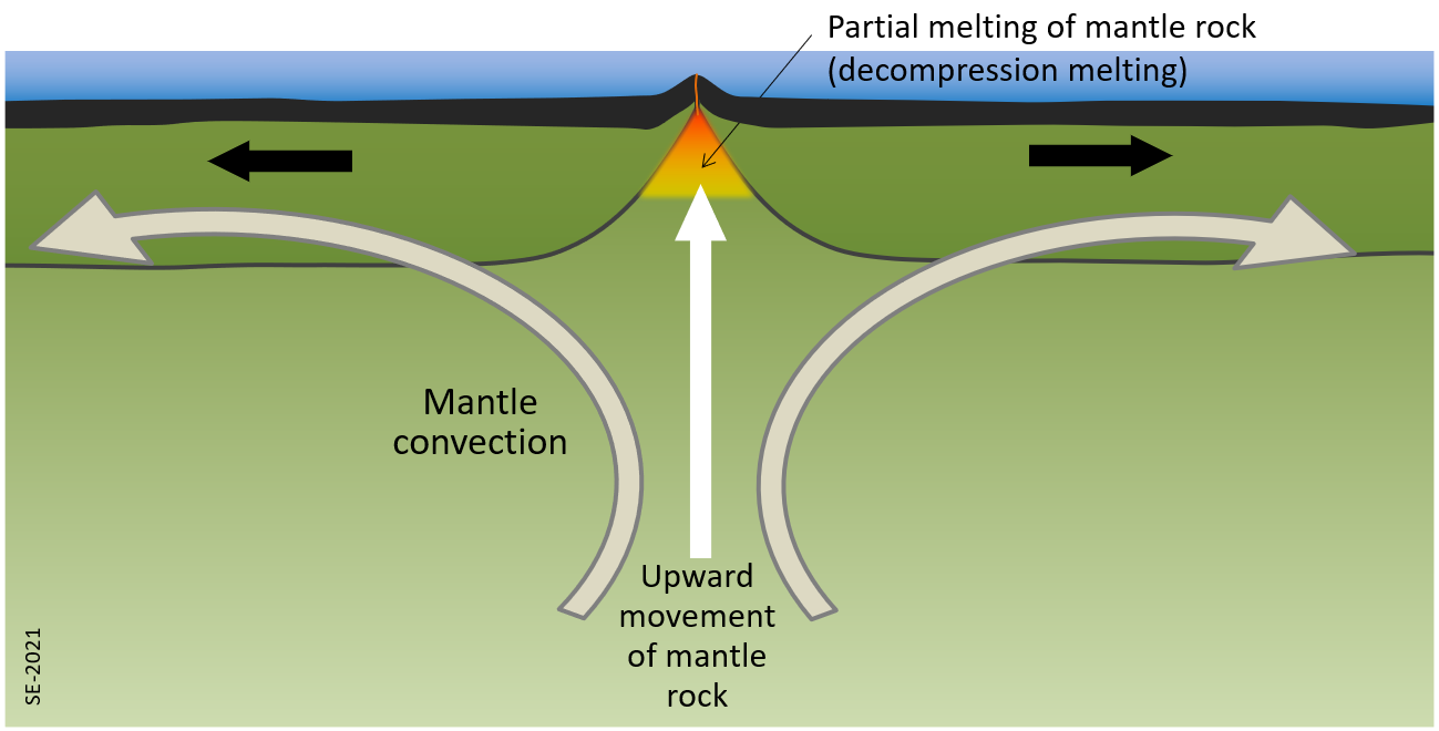
A divergent boundary exists where two plates are moving apart from each other, likely in response to convection in the mantle. This means that there is slow upward movement of mantle rock along the ridge axis. As the hot mantle rock moves upward it experiences reduced pressure which brings it closer to its melting point (decompression melting). Some of it (approximately 10%) melts, producing mafic magma that erupts at surface (in this case on the sea floor) to form basalt, and also cools beneath surface to form gabbro. New oceanic crust is made in this way.
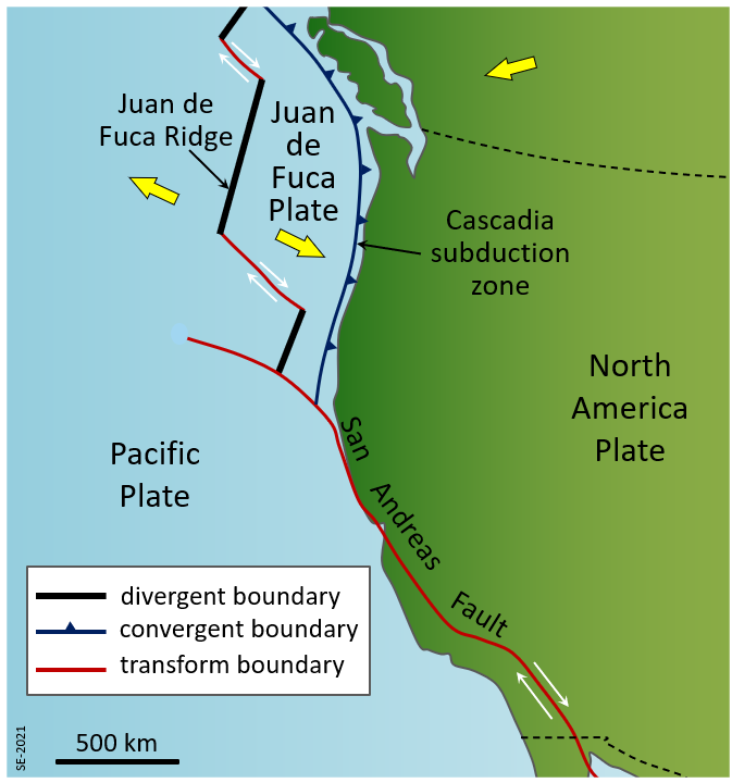
Some plate boundaries are shown in plan view on Figure 2.4.5. The Juan de Fuca Ridge, where the Juan de Fuca and Pacific Plates are moving away from each other and new oceanic crust is being made, is an example of a divergent boundary. The Cascadia Subduction Zone is an example of a convergent boundary. Here the Juan de Fuca Plate is pushing down underneath the North America Plate, resulting in earthquakes and volcanoes.
The third type of plate boundary—a transform boundary—where two plates are moving side-by-side relative to each other, also exists in this region. An example is the San Andreas Fault, which forms the boundary between the North America and Pacific Plates through California. The relative motion of these two plates is shown with small white arrows. There have been large earthquakes along this boundary, and there are frequent smaller ones.
Two smaller transform boundary segments are shown (as red lines) on the map, between the segments of the Juan de Fuca Ridge. In both cases the Juan de Fuca Plate is moving relative to the Pacific Plate, and there are frequent small earthquakes along these boundaries.
Exercise 2.4 Plate Boundary Processes
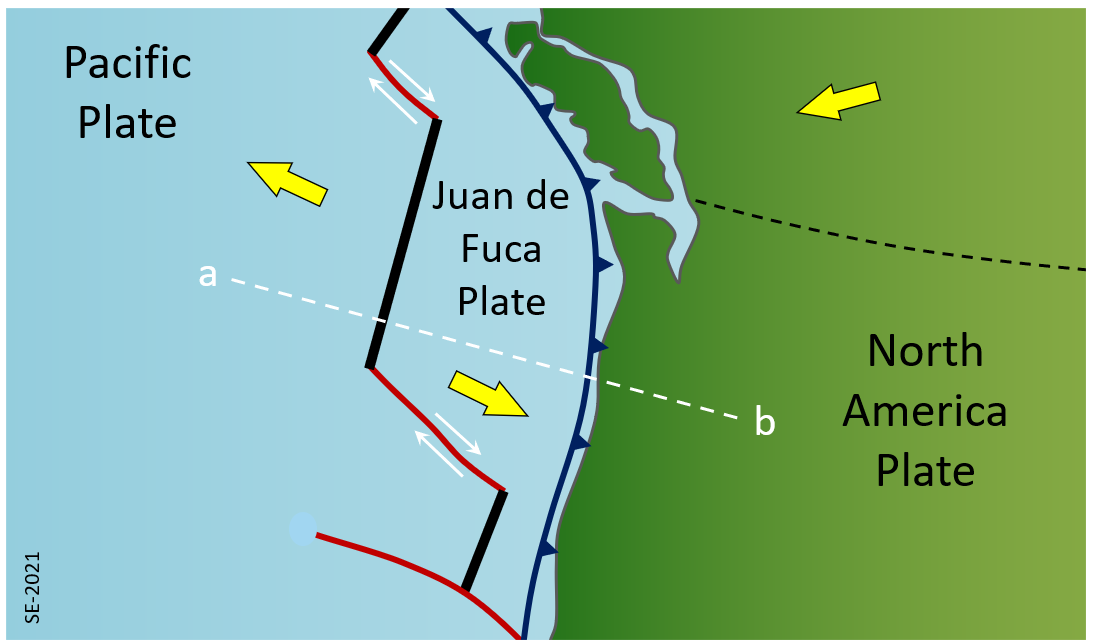
Using Figures 2.4.2 and 2.4.4 as examples, draw a cross section through the crust and upper mantle along the white dashed line labelled a-b on Figure 2.4.6 below. Label the plates and show their motion directions with arrows. Indicate where there might be earthquakes and volcanic activity.
Exercise answers are provided Appendix 2.
Field Trip 2.1
Okay, it’s not really a field trip, but have you ever been to a different country or a different continent? If so, what plate were you on? Or, if you’ve been on several overseas trips, what plates have you been on in your lifetime?
You can also think of an exotic place that you’d like to visit and figure out what plate you will be on if you ever go there.
Figure 2.4.1 above should help you answer this question.