4.1 Glacial Periods in Earth’s History
Steve Earle
We are currently in the middle of a glacial period that started about 34 million years ago, but became more intense about one million years ago. During that time glaciers have expanded and contracted on a time scale of around 100,000 years. As described in Chapter 3, this is not the only period of glaciation in Earth’s history; there have been many in the distant past, and the more significant ones are shown on Figure 4.1.1. In general, however, the Earth has been warm enough to be ice-free for much more of the time than it has been cold enough to be glaciated.
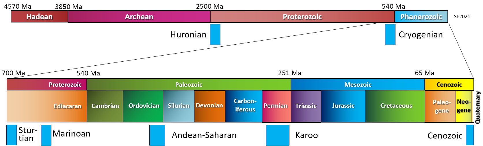
The oldest known glacial period is the Huronian, and as we’ve seen, it was likely initiated because of the evolution of photosynthetic organisms. This resulted in an increase of free oxygen in the atmosphere and a consequent drop in the levels of the greenhouse gas methane—which triggered cooling. Based on evidence of glacial deposits from the area around Lake Huron in Ontario (and elsewhere), the Huronian glaciation lasted from approximately 2450 to 2400 Ma. Because rocks of that age are rare, we don’t know much about its intensity or global extent.
Late in the Proterozoic the climate cooled dramatically and the Earth was gripped by what appears to be the most intense glaciation ever. This may have been a result of a concentration of continents near to the equator, which had an albedo-related cooling effect (See figure 3.2.1). The glaciations of the Cryogenian Period (cryo is Latin for icy-cold) are also known as the Snowball Earth glaciations, because it is hypothesized that the entire planet was frozen—even in equatorial regions—with ice on the oceans up to several hundred metres thick. A visitor to our planet at that time might not have held out much hope for its habitability, although life still survived in the oceans. There were two main glacial periods within the Cryogenian, the Sturtian from 720 to 660 Ma, and the Marinoan from 645 Ma to 635 Ma. The end of the Cryogenian glaciations coincides with the evolution of relatively large and complex life forms on Earth. Some geologists think that the changing environmental conditions of the Cryogenian are what triggered the evolution of large and complex life first observed in the rocks of the late Proterozoic[1] and then continuing with so-called “explosion” of life forms in the Cambrian.
As shown on Figure 4.1.1, there have been four major glaciations during the Phanerozoic (the past 540 million years), including the Andean/Saharan, the Late Devonian, the Karoo and the Cenozoic glaciations.
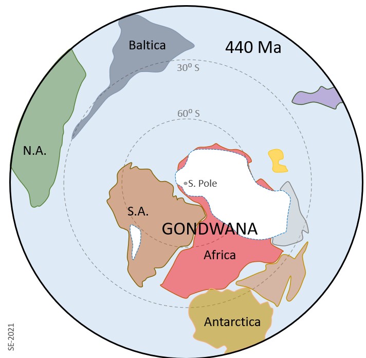
Evidence for the Andean-Saharan glaciation is found in rocks of the Andean region of South America and in the Sahara region of Africa during the Ordovician and Silurian (Figure 4.1.2). The glaciation may have lasted for up to 10 million years (from about 435 to 445 Ma) at a time when the supercontinent Gondwana was mostly close to the South Pole. Eyles (2008)[2] has suggested that the cooling that triggered this glacial episode might have resulted from the formation of a major mountain range in the northern part of what is now Africa, which, as discussed in Chapter 3, would have led to enhanced erosion and weathering, and therefore to consumption of atmospheric carbon dioxide.
Eyles (2008) describes the glaciation in the late Devonian (around 375 Ma) as being “short-lived”, although the volume of ice may have been similar to what is present on Earth now. This glaciation, which is recorded in rocks of Bolivia and Brazil, is also though to have been the result of uplift related to mountain building at continent-continent collisions associated with the formation of the Pangea supercontinent.
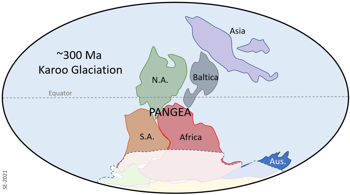
The Karoo was the longest of the Phanerozoic glaciations, and perhaps the longest of all known glaciations (although not the coldest), persisting from approximately 360 to 260 Ma – which includes the latest Devonian, all of the Carboniferous and much of the Permian. For most of that time that the southern (Gondwana) part of Pangea was still situated over the South Pole (Figure 4.1.3). The glaciation is named after a sequence of rocks in southern Africa (Karoo Supergroup), but there is abundant evidence for coincident glaciation in South America, Australia and Antarctica.
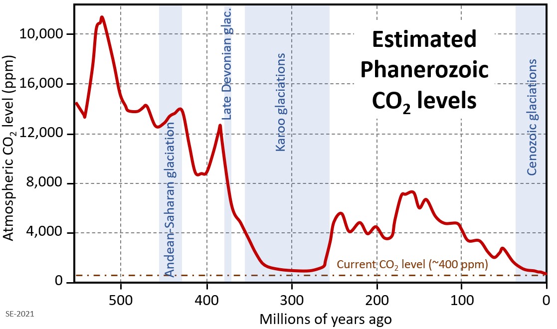
In the late 20th century Yale University geochemist Robert Berner devised a way to use geological data, including sediment volumes and isotopic compositions, to estimate the composition of the atmosphere during the Phanerozoic (the last 540 million years). The results of that work are summarized on Figure 4.1.4, along with the durations of the major Phanerozoic glaciations. The Karoo glaciation is coincident with a period of persistent significantly low CO2 levels, which, according to Berner are a result of enhanced weathering and the consequent consumption of CO2. The strong weathering is mostly ascribed to crustal uplift from collisions, but is also a product of vigorous plant growth at this time. The world’s first forests evolved at around 385 Ma,[3] and the roots of those trees are thought to have played a significant role in loosening the soil and breaking up near-surface rock, making it more susceptible to weathering because tree roots loosen the soil and break up near-surface rocks, making both more susceptible to chemical weathering. Forests would also have had a direct role in removing CO2 from the atmosphere, and some of that would have been permanently sequestered in organic-rich sediments and coal (which first started to accumulate at around this time).
The Earth was warm and essentially unglaciated throughout the Mesozoic. Although there may have been some alpine glaciation at this time, there is no longer any record of it; the dinosaurs, which dominated terrestrial habitats during the Mesozoic, did not have to endure icy conditions.
A warm climate persisted into the Cenozoic, in fact there is evidence that the late Paleocene and early Eocene (~55 to 45 Ma) were the warmest parts of the Phanerozoic since the Cambrian (Figure 3.2.3). As discussed in section 3.4, a number of tectonic events during the Cenozoic contributed to persistent and significant planetary cooling since 45 Ma. For example, the collision of India with Asia, and the formation of the Himalayan range and Tibetan Plateau, resulted in a dramatic increase in the rate of weathering and erosion. Higher than normal rates of weathering of rocks with silicate minerals, especially feldspar, consumes carbon dioxide from the atmosphere and therefore reduces the greenhouse effect, resulting in long-term cooling.
At 40 Ma ongoing plate motion widened the narrow gap between South America and Antarctica resulting in the opening of the Drake Passage. This allowed for the unrestricted west-to-east flow of water around Antarctica, the Antarctic Circumpolar Current (Figure 3.2.4), which effectively isolated the Southern Ocean from the warmer waters of the Pacific, Atlantic and Indian Oceans. The region cooled significantly, and by 35 Ma (Oligocene) glaciers had formed on Antarctica, the first in over 200 million years.
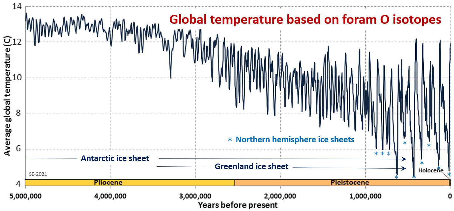
Global temperatures remained relatively steady during the Oligocene and early Miocene, and the Antarctic glaciation waned during that time. At around 15 Ma subduction-related volcanism between central and South America created the connection between North and South America, preventing water from flowing between the Pacific and Atlantic Oceans (Figure 3.2.5). This further restricted the transfer of heat from the tropics to the poles leading to a rejuvenation of the Antarctic glaciation. The expansion of that ice sheet increased the Earth’s reflectivity enough to promote a positive feedback loop of further cooling: more reflective glacial ice, more cooling, more ice, etc. Ice sheets started to grow in Greenland by around 3.5 Ma, and in North America and northern Europe by around 1 Ma (Figure 4.1.5). The most intense part of the current (“Pleistocene”) glaciation—and the coldest climate—was during the Pleistocene, but if we count Antarctic glaciation it really extends from the Oligocene to the Holocene, and will likely continue into the future.
The Pleistocene has been characterized by significant temperature variations (through a range of approximately 8˚ C) on time scales of 40,000 to 100,000 years, and to corresponding expansion and contraction of ice sheets in the northern hemisphere. These variations are attributed to subtle changes in the orbital parameters of the Earth (Milankovitch Cycles), which are described in section 3.4. Over the past million years the glaciation cycles have been approximately 100,000 years, and this variability is clearly visible on Figure 4.1.5.
Exercise 4.1 Pleistocene Glacials and Interglacials
Figure 4.1.6 shows the past 500,000 y of the same data set shown in Figure 4.1.5 . The last five glacial periods are marked with snowflakes. The most recent one, which peaked at around 20 ka, is known as the Wisconsin Glaciation. Describe the nature of temperature changes that led up to each of these glacial periods, and how the temperature changed in the immediate post-glacial period.
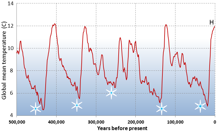
The current interglacial (Holocene) is marked with an H. Identify the previous five interglacial periods.
Exercise answers are provided Appendix 2.
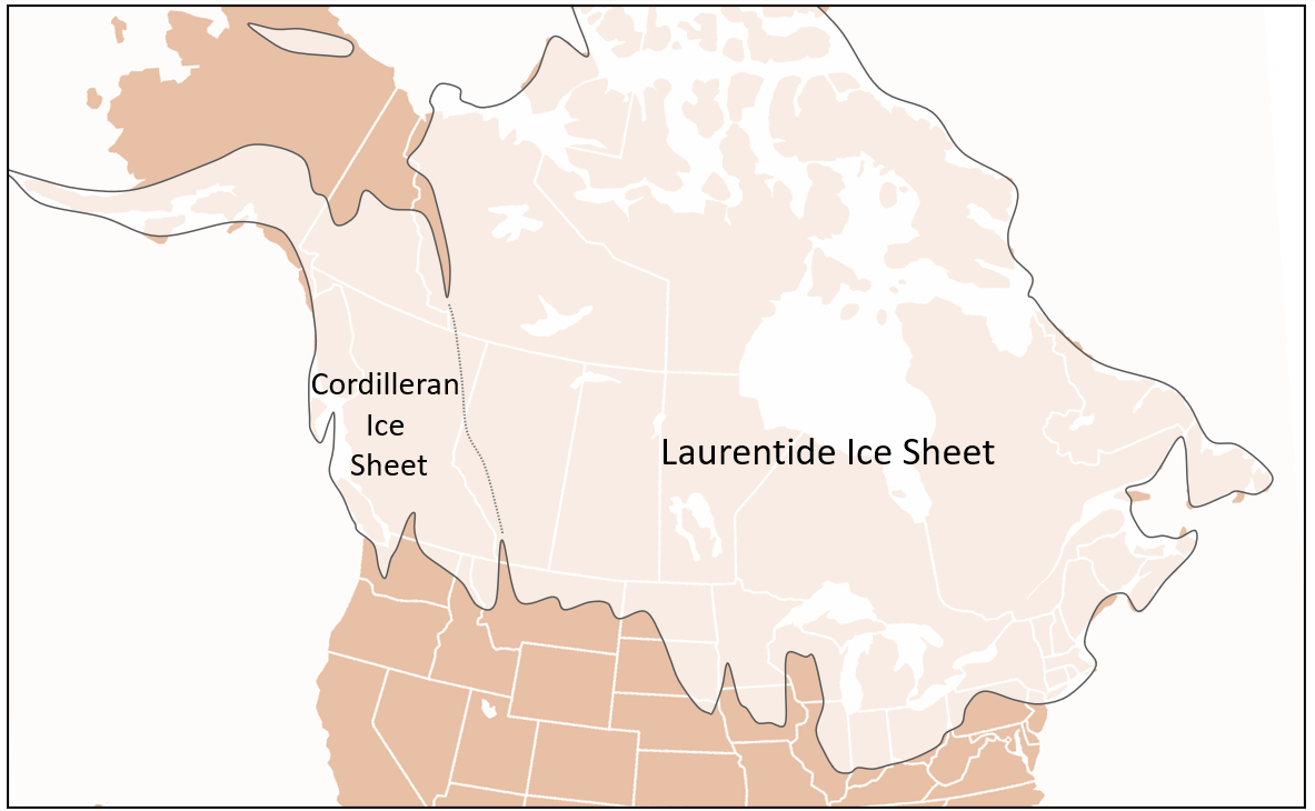
At the height of the last glaciation (Wisconsin Glaciation) massive ice sheets covered virtually all of Canada and much of the northern United States (Figure 4.1.7). The massive Laurentide Ice Sheet covered most of eastern Canada, as far west as the Rockies, and the smaller Cordilleran Ice Sheet covered most of the western region. At various other glacial peaks during the Pleistocene and Pliocene the ice extent was similar to this, and in some cases even more extensive. The combined Laurentide and Cordilleran Ice Sheets were comparable in volume to the current Antarctic Ice Sheet.
Media Attributions
- Figure 4.1.1 Steven Earle, CC BY 4.0, after the International Geological Timescale, https://stratigraphy.org/chart
- Figure 4.1.2 Steven Earle, CC BY 4.0, after Eyles, N. (2008)
- Figure 4.1.3 Steven Earle, CC BY 4.0, after Eyles, N. (2008)
- Figure 4.1.4 Steven Earle, CC BY 4.0, based on data in: Berner, R. A., & Kothavala, Z. (2001). GEOCARB III: A revised model of atmospheric CO2 over Phanerozoic time. American Journal of Science, 301, 182–204. https://doi.org/10.2475/ajs.301.2.182
- Figure 4.1.5 Steven Earle, CC BY 4.0) from Lisiecki, L. E., & Raymo, M. E. (2005). A Pliocene-Pleistocene stack of 57 globally distributed benthic d18O records. Paleoceanography, 20, PA1003. https://doi.org/10.1029/2004PA001071
- Figure 4.1.6 Steven Earle, CC BY 4.0, using data from Lisiecki & Raymo (2005)
- Figure 4.1.7 Steven Earle, CC BY 4.0, based on a public domain NOAA map, Paleo Glaciation, https://www.ncdc.noaa.gov/paleo/glaciation.html
- Hoffman, P. F., Abbot, D. S., Ashkenazy, Y., … Warren, S. G. (2017). Snowball Earth climate dynamics and Cryogenian geology-geobiology. Science Advances, 3(11), e1600983. https://doi.org/10.1126/sciadv.1600983 ↵
- Eyles, N. (2008). Glacio-epochs and the supercontinent cycle after ∼3.0 Ga: tectonic boundary conditions for glaciation. Palaeogeography, Palaeoclimatology, Palaeoecology, 258(1–2), 89–129. https://doi.org/10.1016/j.palaeo.2007.09.021 ↵
- Berry, C. (2019). Palaeobotany: The rise of the Earth’s early forests. Current Biology, 29(16), R792-R794. https://doi.org/10.1016/j.cub.2019.07.016 ↵